21st Oct,2008.
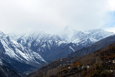
The first thing I realized on waking up in the freezing cold was the heart warming sight of bright sunshine peeping in through the window. As we came out in the balcony, the view of crystal clear blue skies and sunlit white peaks gave us the much required hope to carry on the trip.
As we met up with the driver, he too suggested it should be fine to move on.
We were in a surprisingly good mood today compared to the night before, perhaps something to do with the high altitude taking it's toll in the evenings. It's happened to me before at Gangotri in 2006, when I was terribly depressed and had a feeling of impending doom at night, but just like today it was gone the next morning.
Or our immunity could be the effect of Anti mountain sickness (Diamox) pills which we popped in last night, and on which I could write an entire post, but maybe i'll save that for later.
Though we were ready to leave by 5:30am(we wanted to cover the next 300 odd kms asap while the weather was still clear), the driver suggested we leave by 6:30 as he calculated that it would give sufficient time for any ice accumulated on the high pass to have melted when we reached there.
Soon after we started we crossed the next small settlement of Jispa and reached the final human habitation for next 300 kms, a village called Darcha where we halted for breakfast. Darcha is also the starting point for the famous 20 day Lamayuru trek.
The next stop was just 16 km from Darcha at the most beautiful sight yet, a small high altitude lake (more of a pond) called DeepakTal, with a near perfect reflection of the ChandraBhaga peaks behind; and the picture we took here was perhaps among the best in the trip, which says a lot considering the fact that almost all were out of this world. Our driver also collected some mud from here to use on the icy roads later to prevent skidding.
Now we started with our first real ascent and the views again changed dramatically as we entered the Greater Himalayas.
The Himalayas can be broadly categorised into following ranges in the North: The Dhauladhar range or Lesser Himalayas which includes Dharamshala,Dalhousie and uptil Patni top pass between Jammu and Srinagar, The Middle Himalayas or Pir Panjal range extending from Gulmarg in Kashmir to Lahaul and Rohtang in Himachal, and the Greater Himalayas beyond this which contain some of the world's highest peaks.
It takes some time to really appreciate the towering stature of Himalayas among the world's mountains -more than top 100 of world's highest peaks are located here, in fact the highest peak outside this region is Mt. Aconcagua in Andes in South America, which at 22,841 ft it's still 1000 ft shorter than the 100th ranking Himalayan peak(and Everest is 29,000!).
No wonder then that they're the Grand Daddy's of mountains, with a veritable embarassment of riches bestowed upon them.


Soon we entered the snow country of ChandraBhaga glacier, and the temperature dipped a few degrees further down.It was white as far as the eye could see, and the driver showed us the spot where 5 people had died in an avalanche just about a month back. We did feel a little nervous here since we could see the wind blowing off freshly fallen snow just above the road. As we reached the first major pass BaralachaLa at 16,400 ft, we got down for a quick photo op. The lake below the pass-SurajTal, had completely frozen over, though this was just the beginning of winters.

We quickly realised how deceptively deadly this otherwise beautiful view could be, since though we were out for just 3-4 minutes, yet our hands and faces had gone completely numb in the cold and had to be vigorously rubbed back to life.
I wondered how many minutes would it take for a person to get hypothermia here if stranded alone- not too many for sure.
Getting down the northern side of BaralachaLa we got our first glimpse of the dry high mountain desert that is Ladakh.
We soon touched Sarchu in the Lingti plains, where we saw a completely different landscape at 13000 ft. This serves as a camping ground for travellers during peak season (though sleeping at this altitude without acclimatisation is a sureshot invitation to mountain sickness)
Again there was no sign of life anywhere in this stretch, but our gasps of surprise and exclamations of delight at the vistas commenced here. Me and Hari kept shuffling the cameras between us depending on which side window offered a better view, and trust me it wasn't easy to decide !

The valley was divided by the Lingti river, and beautiful formations of stalagmite and stalactites accompanied us all along.

As soon as we crossed the Lingti nallah we were officially inside the state of Jammu & Kashmir and India's largest district of Ladakh.
We begin climbing the circuitous 21 hairpin bends known as Gatta loops, which would eventually elevate us from valley floor to a height of 16,616 ft to the second pass LachulungLa.


The pass in itself was not very significant, and we descended from this peak again to the valley of Pang.


Here, for the first time in the trip, we saw a sign of habitation, a tent put up by group of 5-6 Ladakhi women to serve as a makeshift dhaba, where the ITBP jawans were enjoying themselves to a cup of tea and maggie. It was 2 pm and our driver also needed a break from driving, so we had lunch of hot maggie with traditional Ladakhi butter tea here, with the butter said to energize against the biting cold.
Ascending from here we soon entered the Morre plains, which is a flat plateau at 16,000 ft! The stunning views here were among the best in the entire 7 day trip, since we had snow capped peaks just in the immediate vicinity, which for a change were not towering above us but seemed to be almost approachable.


No wonder this route is said to be among the best for motorcycle rides in the world, I made a pledge here to be back some day, hopefully on my Thunderbird.
There's again an ascent to the second highest pass of the world, also the third and final barrier to Leh- TaglangLa at 17,582 ft. We got out and clicked some pics as it offered jaw dropping views to the valleys and peaks on both sides, with the Karakoram range also visible up North.This incidentally also happened to be the very place where the Kargil war in Lakshaya was filmed.


From here it was a descent and 2 hours drive to the first Ladakhi village Upshi, a whole new world altogether. The people, the housing style, the language, everything had changed by now. One could almost feel as if one was in Tibet.

We reached Leh by 7 pm, and our driver took us to the Hotel Tso-Morri's, comfortably located in the heart of Leh, just across the main bazaar. It was dark already and the night temperature was dipping to -7 in Leh, so we just went to a Tibetan restaurant in the bazaar for some hot soup and momos, and settled down in our hotel for a much deserved night's sleep!


